
Record-warm Pacific waters are raising the odds of floods, coastal damage and health risks, with communities across California being
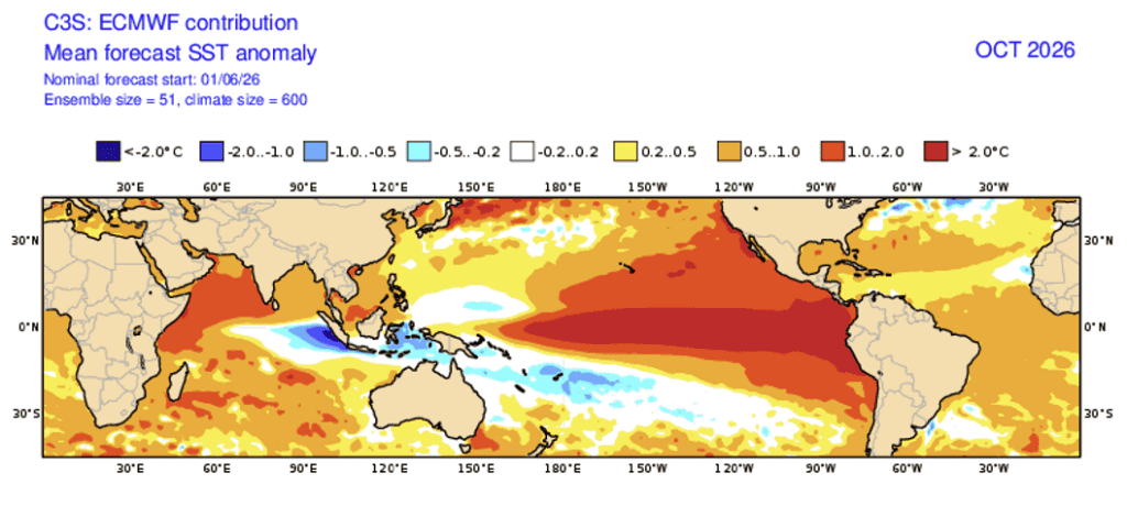
Something powerful is stirring in the Pacific.
Thousands of miles from California’s neighborhoods, farms, and coastlines, waters in the eastern tropical Pacific have warmed at an extraordinary pace. The change is happening far from most of our daily lives, but oceans have a way of reminding us that distance does not mean disconnection.
The warming is part of a developing El Niño that climate scientist Dr. Daniel Swain says is already breaking records for this time of year. Forecasts suggest it could become one of the strongest El Niño events scientists have observed.
What happens next will not remain somewhere out at sea.
For California, the effects could eventually be felt in flooded neighborhoods, damaged coastlines, unusually humid heat, heavy winter rain and communities confronting another season of extreme weather.
“El Niño has arrived, and it’s continuing to get stronger,” Swain said.
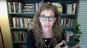
Swain, an associate researcher at the California Institute for Water Resources at the University of California Agriculture and Natural Resources and a research partner with the NSF National Center for Atmospheric Research, described forecasts so unusual that even the phrase “super El Niño” may not fully capture what scientists are watching.
He discussed the developing event during an American Community Media ethnic media briefing focused on what El Niño could mean for California and the rest of the country. The conversation moved beyond dramatic weather headlines to a more important question: What happens when an exceptionally strong natural climate cycle collides with a planet already made warmer by human-caused climate change?
There is no official scientific category called “super El Niño,” Swain explained. The phrase is generally used to describe a very strong event.
This one could go further.
“Maybe we need a new category of extreme El Niño,” he said, calling the forecast “genuinely extreme.”
A Warming Ocean With a Long Reach
At its simplest, El Niño begins with unusually warm water in the eastern tropical Pacific.
Normally, winds across the Pacific help keep colder water rising near South America. During El Niño, those winds weaken. Cold-water upwelling diminishes while warmer water moves eastward.
Swain compared the process to releasing a stretched spring. He also described El Niño’s wider influence as ripples spreading from a pebble dropped into a pond, strongest near the point of impact but capable of traveling great distances.
Those ripples can alter storm tracks around the world.
El Niño also releases stored ocean heat into the atmosphere, temporarily raising global temperatures. Swain described it as a natural “mini global warming” layered on top of long-term human-caused warming.
That layering matters.
A warmer atmosphere can hold more moisture. Some regions may experience extreme rainfall while others become unusually dry. Heat, drought, flooding, and wildfire risk do not rise everywhere at once, but the odds can shift sharply from place to place.
For California, one of the clearest signals is the possibility of a wetter winter, particularly across central and Southern California.
But Swain was careful about what that means.
El Niño does not guarantee a wet California winter. It does not tell us today which community will flood months from now.
What it does is change the odds.
And with an event this strong, those odds matter.
California Has Something Precious: Time
Swain said El Niño itself would likely reach peak strength sometime between October and December, with November near the center of that window. Yet the strongest effects in California and other regions far from the tropical Pacific tend to come later.
The greatest impacts could arrive between December and March, or even beyond.
That gives California time to prepare.
Some effects are already appearing.
Ocean temperatures off central and Southern California are warmer than average. Subtropical fish and other marine species are moving into areas where they are not normally found, following the warmer water.
For people, those warmer coastal waters can also contribute to higher humidity during late summer and early fall.
Humidity matters because it makes it harder for sweat to evaporate and cool the body. Warm nights can add to the strain by reducing the hours when people recover from daytime heat.
That becomes especially important for people who work outdoors or live without reliable cooling.
It is easy to speak about extreme heat in degrees.
Communities experience it through the hours someone must remain outside to earn a paycheck, through a home that does not cool after sunset, and through the choices families make when staying comfortable also means paying a higher electricity bill.
That is where climate stops being abstract and enters everyday life.
When the Water Begins to Rise
The winter threat is not only about rainfall.
El Niño can temporarily raise sea levels along the California coast, and Swain said that process was already beginning.
Later in the year, several forces could meet at once.
Winter storms can generate large waves. El Niño can temporarily lift coastal water levels. November and December also bring astronomical high tides, often called king tides.
And underneath all of this is a coastline already experiencing long-term sea-level rise from climate change.
Each factor matters on its own.
Together, they can become much more consequential.
Swain warned that the combination could produce significant coastal flooding, including in places people may not immediately think of as coastal.
San Francisco Bay and Monterey Bay are vulnerable, but tidal influence also reaches inland through connected waterways. The Carquinez Strait and parts of the Sacramento-San Joaquin Delta can feel those effects, including areas around Stockton.
In his hometown of San Rafael, Swain pointed to low-lying neighborhoods and apartment buildings in areas already known to flood.
This year, he said, there is a possibility of record-breaking coastal flooding.
Coastal erosion adds another concern. Large waves combined with higher water can damage beaches, bluffs, roads and other infrastructure.
But the risk does not belong only to the dramatic places we associate with natural disasters.
Floodwater can reach an apartment building.
It can close a road someone depends on to get to work.
It can interrupt school.
It can damage a small business.
And while the same storm may pass over an entire city, people do not enter that storm with the same resources.
Some can leave quickly. Others cannot.
Some can absorb several days away from work. Others depend on every shift.
Some have insurance, savings, and somewhere else to stay. Others are already stretching each paycheck across rent, food, transportation and utilities.
Extreme weather exposes those differences. It can turn an environmental hazard into a housing problem, a workplace problem and a health problem.
For California’s immigrant and multilingual communities, there is another consideration: information must reach people before an emergency, in forms they can understand and trust.
That is one reason ethnic media matters in a conversation like this.
The science may begin with ocean temperatures and atmospheric circulation. But the questions families need answered are much closer to home:
Is my neighborhood at risk?
Where do I go if flooding begins?
What happens if I cannot get to work?
Where will emergency information come from?
A Wet Winter Does Not Solve Every Water Problem
Even if California receives abundant precipitation, a warmer winter could change how much of that water becomes mountain snow.
Swain raised the possibility of a “wet, warm winter,” where substantial precipitation falls but snow is concentrated at higher elevations.
That matters because California’s snowpack functions as a natural reservoir, storing winter precipitation and releasing it gradually as temperatures rise.
A winter can therefore be wet without producing the snowpack Californians might expect from rainfall totals alone.
A wetter pattern could also bring some relief to parts of the Southwest and the Colorado River Basin. But one unusually wet season cannot repair a long-term imbalance between water supply and demand or reverse the drying influence of climate change.
Elsewhere, the pattern flips.
Parts of the Pacific Northwest could become drier, while areas of the Southeast may experience a wetter winter.
There is no single American experience of El Niño.
The Health Risks Can Outlast the Storm
Some consequences may not become visible until after the rain stops.
Flooding can affect drinking water and sewage systems. Both floods and drought can create water-quality problems, particularly where infrastructure is already limited.
Swain also pointed to valley fever, an infection caused by a fungus found in soil.
Wet conditions can encourage growth. When the landscape dries again, fungal spores can become airborne as soil is disturbed.
That creates concern for people who spend significant time around exposed soil, including farmworkers, as well as incarcerated people who may have little control over their environmental exposure.
It is a reminder that recovery cannot be measured only by how quickly floodwater disappears.
The weather may move on before its consequences do.
Preparing Without Panicking
There is a difficult balance in communicating any major climate threat.
Say too little, and people may not prepare.
Say too much, and frightening predictions can become sensationalized.
Swain warned about exactly that cycle. Exaggerated claims can spread quickly, forcing scientists to spend so much time correcting them that genuine risks can end up being minimized.
California does not need another reason to panic.
It needs good information.
El Niño cannot tell us today exactly where the worst storm will strike. But uncertainty should not be confused with ignorance.
Scientists know the Pacific is unusually warm.
They know El Niño is strengthening.
They know very strong El Niño events shift the probability of certain weather extremes.
They know elevated coastal waters, high tides, and large winter waves can be a dangerous combination.
And they know which communities and landscapes have flooded before.
That is enough knowledge to act on.
Residents in flood-prone areas can learn evacuation routes and understand their flood risk. Families can keep important documents protected and accessible. Local governments can inspect drainage systems and review emergency plans before storms arrive.
Public agencies can make sure warnings are available in the languages spoken by the communities they serve.
And trusted institutions—from schools and faith organizations to neighborhood groups and ethnic media—can help turn a complicated climate forecast into information people can actually use.
Because resilience is not simply rebuilding after something goes wrong.
It is giving people the knowledge and resources to protect themselves before it does.
Swain put the opportunity plainly.
“We actually have a fairly long runway in front of us before most of the negative impacts might materialize,” he said. “So that gives us some real time to do something about it.”
That may be the most important forecast of all.
The ocean is already changing. The strongest impacts have not yet arrived.
Between those two realities is a window California cannot afford to waste.
#ElNino #CaliforniaWeather #FloodPreparedness #ClimateChange #ExtremeWeather #CommunityResilience #ClimateHealth #ImmigrantVoices #California





1 Comment. Leave new
[435848]supplies professional anti-violence equipments and solutions for the whole world with strong and perfect production capacity. anti-violence.org